Electoral district of Rodney
| Rodney Victoria—Legislative Assembly | |
|---|---|
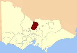
 Location in Victoria, 1856 | |
| State | Victoria |
| Created | 1856 |
| Abolished | 2014 |
| Electors | 36,437 (2010) |
| Area | 7,808 km2 (3,014.7 sq mi) |
| Demographic | Rural |
| Coordinates | 36°20′S 144°55′E / 36.333°S 144.917°E |
The Electoral district of Rodney was a Victorian Legislative Assembly electorate in Northern Victoria.
The Rodney District covered an area of 7,808 square kilometres, including the towns of Echuca, Rochester, Nathalia, Cohuna, Heathcote, Gunbower, Kyabram, Rushworth and Stanhope.
At inception in 1856, the district boundaries include the Murray River and Goulburn River in the north and east; and the Campaspe River in the west.[1] By 1956 the district had expanded further westward to include Cohuna.[2]
In 2014, it was abolished and became part of the electoral district of Murray Plains.[3]
Electoral history
[edit]Until its abolition, Rodney was one of only four electorates (along with Brighton, Richmond and Williamstown) to have been contested at every election since 1856. It was held by the Victorian Farmers Union/Country/National Party from 1917. John Allan, who was the first Country Party Member for the district, became Australia's first Country Party Premier in 1924.
In the 2006 election, Paul Weller won the seat for the National Party with a margin of 4.39% against the Liberals. The Liberal Party did not run in this electorate in the 2010 election, leaving the Nationals with a much higher lead against the other parties.
Members for Rodney
[edit]| Member 1 | Party | Term | |||||
|---|---|---|---|---|---|---|---|
| John Baragwanath | Unaligned | 1856–1857 | |||||
| John Everard | Liberal | 1858–1859 | |||||
| Wilson Gray | Liberal | 1860–1862 | |||||
| John MacGregor | Unaligned | 1862–1874 | |||||
| Simon Fraser | Ministerial[4] | 1874–1883 | Member 2 | Party | Term | ||
| Duncan Gillies | Ministerial[4] | 1877–1889 | |||||
| James Shackell | Conservative/Ministerial[5] | 1883–1892 | William Webb | Ministerial[5] | 1889–1897 | ||
| Timothy Murphy | Liberal | 1892–1894 | |||||
| Andrew White | Unaligned | 1894–1897 | |||||
| John Mason | Liberal | 1897–1902 | John Morrissey | Liberal | 1897–1904 | ||
| Samuel Lancaster | Conservative | 1904–1904 | |||||
| Hugh McKenzie | Independent | 1904–1917 | |||||
| Commonwealth Liberal | |||||||
| Nationalist | |||||||
| John Allan | Country | 1917–1936 | |||||
| William Dunstone | Country | 1936–1944 | |||||
| Richard Brose | Country | 1944–1964 | |||||
| Russell McDonald | Country | 1964–1973 | |||||
| Eddie Hann | Country | 1973–1975 | |||||
| National Country | 1975–1982 | ||||||
| National | 1982–1989 | ||||||
| Noel Maughan | National | 1989–2006 | |||||
| Paul Weller | National | 2006–2014 | |||||
Election results
[edit]| Party | Candidate | Votes | % | ±% | |
|---|---|---|---|---|---|
| National | Paul Weller | 20,524 | 62.71 | +22.55 | |
| Labor | Vanessa Langford | 5,290 | 16.16 | -1.97 | |
| Country Alliance | Gino D'Angelo | 3,697 | 11.30 | +11.30 | |
| Family First | Serena Moore | 1,872 | 5.72 | +2.33 | |
| Greens | Ian Christoe | 1,348 | 4.12 | +0.92 | |
| Total formal votes | 32,731 | 95.59 | +0.82 | ||
| Informal votes | 1,509 | 4.41 | −0.82 | ||
| Turnout | 34,240 | 93.97 | −0.34 | ||
| Two-party-preferred result | |||||
| National | Paul Weller | 24,947 | 76.16 | +21.96 | |
| Labor | Vanessa Langford | 7,809 | 23.84 | +23.84 | |
| National hold | Swing | +21.96 | |||
See also
[edit]- Parliaments of the Australian states and territories
- List of members of the Victorian Legislative Assembly
External links
[edit]References
[edit]- ^ "Electoral district of Rodney" (map). State Library of Victoria. 1855. Retrieved 7 June 2013.
- ^ "State Electoral districts of Rodney and Murray Valley" (map). State Library of Victoria. 1956. Retrieved 7 June 2013.
- ^ "No change to Murray Plains". Gannawarra Times. 6 October 2022. Retrieved 3 December 2022.
- ^ a b "The New Victorian Legislative Assembly". South Australian Register. 19 May 1877. Retrieved 7 June 2013.
- ^ a b "The General Election". Gippsland Times. Trove. 29 March 1889. Retrieved 7 June 2013.
- "Re-Member (Former Members)". State Government of Victoria. Retrieved 21 April 2013.
